
| Briefing | Tuesday 27th May, 2014 |
| Start Time and Place | 19:00zulu (8pm local) on 27th outside the Club hangar at Gloucester, or any time during the week 25th to 31st May 2014. |
| Airmanship | This will be a challenging flight as Popham is small airfield with grass runways and no navaids to assist with locating it on the final leg. Good visual navigation is needed to ensure that one reaches the overhead for landing. Once at the airfield there are a lot of trees around so the approaches to Runway 08/26 are both not along the centre line and involve a turn when on very short final. |
| Weather ...or not | Before starting we will check the weather. If it is unsuitable for our trip as planned, then we will fix it. Something we can do in the simulator - wouldn't it be nice if we could do it in real life! For the general handling we need a cloud base that is at least 3000ft AGL. FSInn has a "CAVOK" button. Click this and you get calm clear weather. Those using SB will need to turn off the on-line weather updates, and select calm in the FS weather options. |
| Flight Plan |
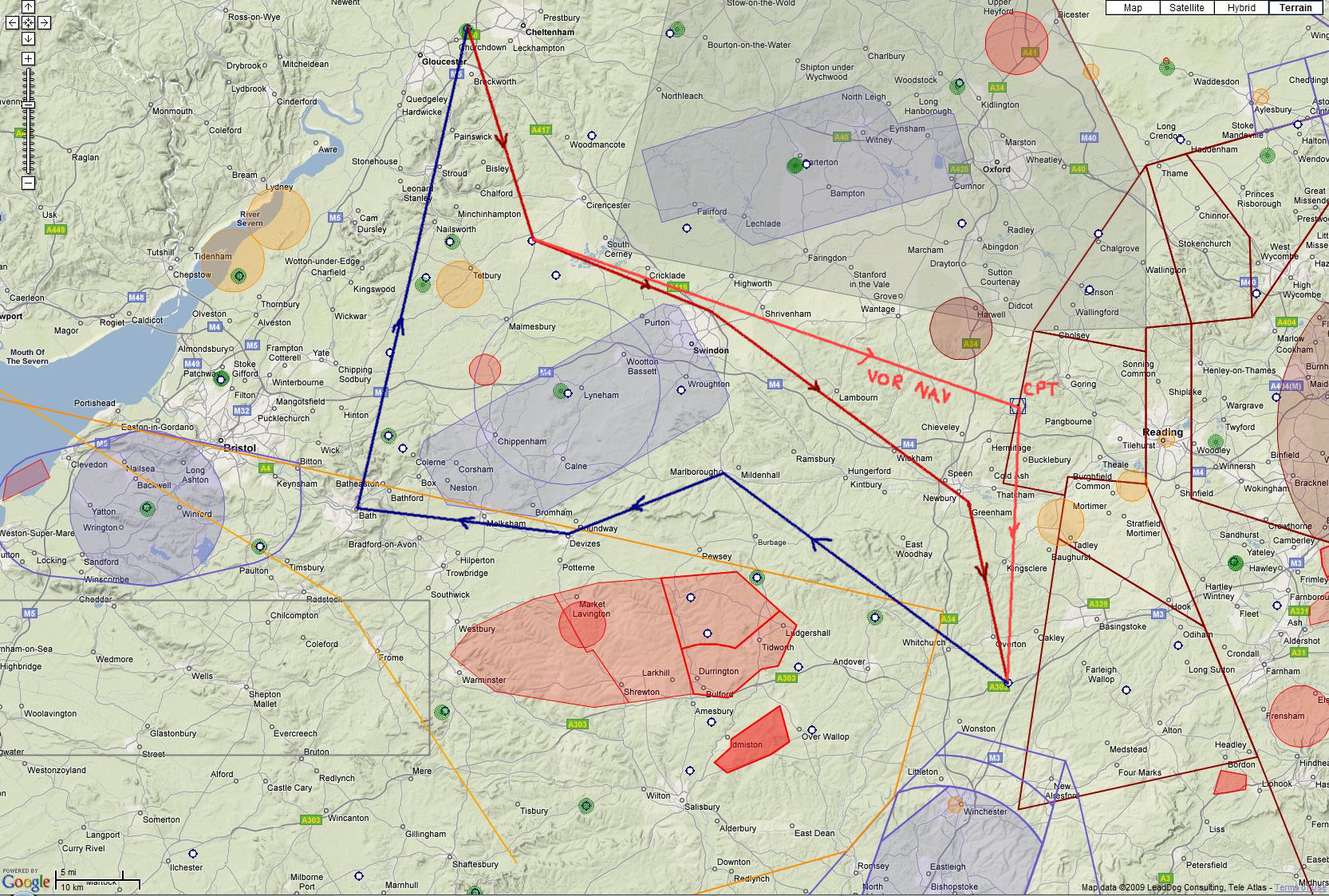
Outbound Flight: EGBJ - EGHP Route: Gloucester - Kemble - Swindon - Greenham Common - Popham Comments = /V/ DAYLIGHT / CIX VFR CLUB Return Flight: EGHP - EGBJ Route: Popham - Marlborough - Devizes - Bath - Gloucester Comments = /V/ DAYLIGHT / CIX VFR CLUB All bearings and headings given in the briefing below are magnetic, and no allowance has been made for any cross wind. Airfield charts and information for UK are available from the AIS web site. Unfortunately this does not include EGHP Popham, however a sketch of the airfield was prepared for the event - see the Popham section below for a link. |
| Outbound Route Details |
Gloucester - Kemble
After departing Kemble, head 167º over the hill to Kemble. Maximum elevation over the hill is 1400ft, so you should aim to climb to a minimum altitude of 2400ft. Just before Kemble you will pass Aston Down, a popular gliding site. We are told that there's no gliding taking place today, but keep 'em peeled, as you never know. Kemble - Swindon Turn to a heading of 115º and head towards Swindon. We are passing between two busy pieces of military airspace -- Lyneham CTR and Fairford MATZ, so watch your heading. Do not climb above 4400ft. We are allowed through the Fairford MATZ, although we must keep out of the ATZ, therefore make sure you keep the A419 on your left. Swindon - Greenham Common Turn to a heading of 131º . Keep close to the A419 as it passes round the North Eastern side of Swindon. We're very close to the edge of Lyneham's airspace (it covers half the town), and infringements will not be welcome. Also avoid flying directly over Redlands airfield, as it's a parachute site, and it would be unfortunate for a 'meat bomb' to land on top of you. After Swindon, we will pick up the M4 and can pretty much follow the motorway as far as Newbury. Greenham Common is a large disused US air base from the Cold War era, just to the South East of the town. It's easily identified from the photographic scenery Greenham Common - Popham Our final heading is 168º , and that will take us directly to Popham. Popham is on the North side of the A303, close to the junction with the M3. Alternatively, for those who fancy a bit of more advanced Navaid training on the way out, the Compton VOR (CPT 114.35MHz) will take you from all the way from Kemble to Popham, missing out the turns at Swindon and Newbury. First fly TO the beacon (set 113º on the OBS with the To/From flag (the little white arrow) pointing upwards and fly keeping the needle centred) then when you get to about 2 DME (nautical miles) before it, fly the HEADING not the needle, Turn right onto a heading of 186º , and watch the To/From flag change to FROM. Change the OBS setting to 186º degrees. Continue to fly the HEADING and let the needle come in. When you are about 3 - 4 miles DME it should be roughly centred. If not correct as required. Popham is 18DME after flying over (i.e. FROM) the VOR. Note that when flying towards the beacon, with the TO flag set you follow the needle. Needle to the right, turn right. When flying away from the beacon, with the FROM flag set, you also follow the needle (Needle to the right, turn right etc.). Heading adjustments should be about 10 degrees unless the needle is right against the stops, indicating that you are some way off the radial. In that case, make a 45 degree turn until the needle centres. One day, for practice, we will do some flying TO a beacon with the FROM flag set - not intuitive, and best (and easily) avoided! |
|
Return Route Details |
Popham - Marlborough
The return flight takes us round the South of Lyneham. From Popham head 310° towards the town of Marlborough. There's not much in the way of line features to follow, but you should pass the town of Andover on your left, and Manor Farm (if you have the farm strips scenery), also on your left. Assume that the Danger Areas D126 and D128 are active, so don't stray too far left of track.
Marlborough - Devizes
|
|
Charts & Map |
 This map is representative of the route described in the briefing. it is not intended to be used for navigation purposes. This map is representative of the route described in the briefing. it is not intended to be used for navigation purposes.Click on the thumbnail for the full size picture. |
|
Training |
If anyone wants to learn how to fly by VOR/DME pairs, you can download the VOR Tracking tutorial from the club web site Training section. |
|
Popham (EGHP) |
Latitude North 51 degrees,11.63 minutes. Longitude West 001 degrees, 14.08 minutes. Airfield elevation is 550 ft above sea level. The Approach to Runway 26 is marked with an arrow about 100 yds from the runway. Fly over the arrow (Approx heading 240) to avoid the trees and the filling station on Short Final. Circuits are at 800' to the north. This is lower than most other airfields. "Circuits to the north" means, of course right-hand for 26 and left hand for 08. Scenery files (version 1.2) by David Humble. For those without UK2000 Airports volume 1: Popham Airfield Scenery includes taxiways and textures and corrections for magnetic variation (2009). |
| Radio | We may have an Air/Ground service on Popham Radio (129.8). This is very similar to an AFIS, providing information rather than control. Each pilot is responsible for his own safety in the circuit and on the ground at Popham. If that doesn't happen, we will be released to approach and land at Popham on the unicom frequency. If all else fails, one of our more experienced members will attempt to keep control on our club TeamSpeak. Whilst we should have a preference for runway 26, the local wind will be the deciding factor. Unless wind speed is less than 5 knots, we will want to land into wind, or with the minimum crosswind. |
|
VOR Tracking |
The
Instrument Flight document in the Training section of the club web site contains a section on VORs and how to use them. If you are unsure how to track a VOR radial, download and have a look at this. The document covers the use of NDB and DME for direction and distance measurements as well. |
|
Radio Discipline |
Take care not to let our Teamspeak chat cut across ATC. Stop any conversation immediately the R/T comes alive, then continue if "he wasn't talking to us". This is difficult because when transmitting on Teamspeak you can't hear the R/T. So be brief on Teamspeak, and be aware that ATC might be trying to get through. If anyone hears an R/T message which seems to be being ignored, just say "ATC is calling G-CIXN" if you have identified the callsign, or "ATC is calling us" which is a cue for everyone to be quiet on Teamspeak until ATC call again (which they will). Remember too that if asked to "Stand By" by ATC, you do not reply - not even "Roger", but simply wait until you are called again. Remember also that there are several different ATC frequencies in use, and you may not be able to hear when communications are taking place. Make sure you have set and know how to use a Teamspeak mute switch. |
|
|
|
Version 2.0 - 06:00 ZULU 03/05/14 |