This year for our annual Christmas Caper we are off to see Santa Claus in his Lapland hideaway. We will be joining in with the annual VATSIM Scandinavia event, and hopefully some of our friends from the Friesenflieger will join us.
Everyone should start at Biggin Hill and plan to arrive at Rovaniemi EFRO (Santa's Airport) on the day of the VATSIM event on 13th December. Each of the listed flights is around one to one and a half hours at 120 knots, so you probably would prefer to use one of the faster aircraft in your fleet for this event. Make sure it is within Club weight limit rules though. You can fly at any time during the day or night, VFR preferably, but IFR if the weather doesn't favour VFR.
From 14th December onwards, if you feel the need for more Christmas Caper flights, you can of course come back home. Feel free to choose your own route, if you wish to do that.
|
| Event Rules |
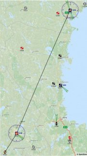
- Phase 1 is a trip from Biggin Hill to Wangerooge comprising three legs of approximately 1 hour each.
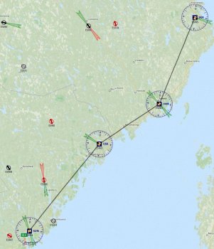
- Phase 2 is a trip from Wangerooge to Rovaniemi, comprising 7 legs, each between one and one and a half hours except the last one which is only 30 minutes.
- You must complete Phase 1 in November, and complete Phase 2 on or before 13th December.
- You can begin the trip any time during November. However, you cannot depart from Wangerooge until December 1st.
- A star will be awarded for arriving at Wangerooge during November and a second star will be awarded for arriving at Rovaniemi. The December star will be a special one, if you join in with the VATSIM "Fly to see Santa" event on 13th December.
- You can fly each leg separately or combine them, missing out one or more intermediate landings.
- Remember to put "CIX VFR Club" in the comments section of your flight plans, to comply with general Club Rules, but particularly so on 13th December as we will be on show to a wide VATSIM audience.
|
Weather
...or not |
This event may be flown under Visual or Instrument Flight Rules. Bear in mind that the final destination is on the Arctic Circle, so the last two or three legs may well be flown in darkness, unless you pick the time of your flight very carefully. It is a good idea to brush up on those night flying skills anyway. Remember that all over Europe night-time VFR is permitted. |
| Airspace |
There is a lot of controlled airspace on this trip, so check the boundaries and check the rules.
As you pass Copenhagen going north, you have Class C airspace from 9,500ft upwards for the rest of the trip to Rovaniemi. All Swedish controlled airspace is Class C.
As you cross the 62° North line of latitude during leg 7, you enter Class E airspace from the surface to 9,500ft. You still have Class C airspace from 9,500ft upwards. This continues for the rest of the trip until you reach Tornio-Kemi, where it is all Class D airspace thereafter. |
| Water |
Substantial parts of each leg are flown over large areas of open water. In the real world, it is generally considered high risk to fly over open water in a single engined aircraft, and carrying survival equipment is a must. So if you are flying a single, you can choose to fly a route which minimises over-water sections while still arriving safely at your destination. |
Flight Plans |
Flight Plans
Plan-G flight plans for FSX, FS2004 (FS9), and Xplane 9 and 10 can be found in the Flight Plans ZIP file, which you can download HERE. |
Leg 1
EGKB-EHMZ |
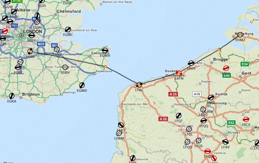
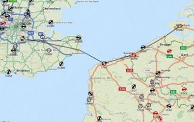 Leg 1 starts off Biggin Hill (EGKB), crosses the English Channel from Dover to Calais, and then continues north along the French coast, past Dunkirk into Belgium, and continues via the KOKSY VOR into the Netherlands via the COSTA VOR to a landing at Midden-Zeeland (EHMZ) near the town of Middelburg. The total time for this leg is 1 hour and 16 minutes.
Navigation Aids and Communications
| Dover VOR |
DVR |
114.95 MHz |
| Koksy VOR |
KOK |
114.50 MHz |
| Costa VOR |
COA |
110.05 MHz |
| Biggin Hill |
EGKB |
Tower 134.80 |
| Middel-Zeeland |
EHMZ |
Multicom 119.25 |
|
Leg 2
EHMZ-EHGG |
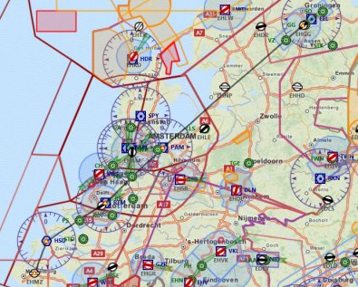 Leg 2 departs from Middel-Zeeland (EHMZ) and follows the coast north to Rotterdam, passing the Haamstede and Rotterdam VORs. The route continues north east, skirting busy Schiphol to the east, past the Pampus VOR. After passing Leystad (EHLE) to starboard, the route, then heads inland to Eele, where this leg ends. Flight time is 1 hour and 6 minutes. Leg 2 departs from Middel-Zeeland (EHMZ) and follows the coast north to Rotterdam, passing the Haamstede and Rotterdam VORs. The route continues north east, skirting busy Schiphol to the east, past the Pampus VOR. After passing Leystad (EHLE) to starboard, the route, then heads inland to Eele, where this leg ends. Flight time is 1 hour and 6 minutes.
Navigation Aids and Communications
| Haamstede VOR |
HSD |
114.15 MHz |
| Rotterdam VOR |
RTM |
110.40 MHz |
| PAMPUS VOR |
PAM |
117.80 MHz |
| Middel-Zeeland |
EHMZ |
Multicom 119.25 |
| Eelde |
EHGG |
Approach - 119.70 |
| Eelde |
EHGG |
Tower - 118.70 |
|
Leg 3
EHGG-EDWG |
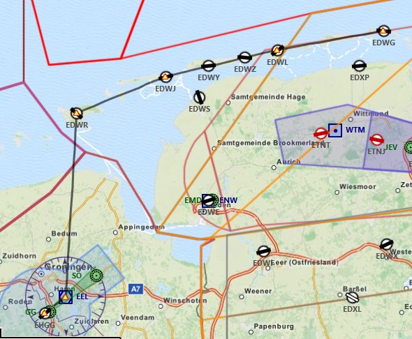
 Leg 3 is a sightseeing tour of the pretty Friesian Island chain. After departing Eelde you will track to the EDE VOR before turning onto a northerly heading. You will coast out about 2nm west of Eemshaven harbour and shortly afterwards enter German airspace. If visibility is good you will spot the most southerly of the Friesian islands, Borkum, ahead. Leg 3 is a sightseeing tour of the pretty Friesian Island chain. After departing Eelde you will track to the EDE VOR before turning onto a northerly heading. You will coast out about 2nm west of Eemshaven harbour and shortly afterwards enter German airspace. If visibility is good you will spot the most southerly of the Friesian islands, Borkum, ahead.
Overfly
Borkum and continue along the island chain to the sixth and last island, Wangerooge, where you will land. Total time for this leg is 40 minutes.
There is no fuel on the island of Wangerooge, so fill up at Eelde. There is a good hotel though, if you are planning to arrive there before 1st December.
Navigation Aids and Communications
| Eelde |
EHGG |
Approach - 119.70 |
| Eelde |
EHGG |
Tower - 118.70 |
| Wangerooge |
EDWG |
Unicom - 122.800 |
|
Leg 4
EDWG-EKKL |
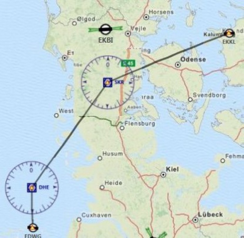
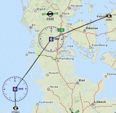 Leg 4 takes you into Denmark. From Wangerooge, head north over the North Sea for the Heligoland VOR on its tiny island with a very interesting history. (You can research that on the web at your leisure). After Heligoland, strike off northeast tracking to the Vogens/Skrydstrup VOR and the Danish Airforce base of the same name. then, turning more easterly, fly on a bearing of 066° pass Odense and the Odin VOR (115.50) (these Norse Gods are everywhere!) to Kalunborg for landing. This leg will take about 1Hr 30 minutes. Leg 4 takes you into Denmark. From Wangerooge, head north over the North Sea for the Heligoland VOR on its tiny island with a very interesting history. (You can research that on the web at your leisure). After Heligoland, strike off northeast tracking to the Vogens/Skrydstrup VOR and the Danish Airforce base of the same name. then, turning more easterly, fly on a bearing of 066° pass Odense and the Odin VOR (115.50) (these Norse Gods are everywhere!) to Kalunborg for landing. This leg will take about 1Hr 30 minutes.
Navigation Aids and Communications
| Heligoland VOR |
DHE |
116.30 MKHz |
| Vogens/Skrydstrup VOR |
SKR |
110.40 MKHz |
| Wangerooge |
EDWG |
Unicom - 122.800 |
| Kalundborg |
EKKL |
Unicom - 122.800 |
|
Leg 5
EKKL-ESGK |
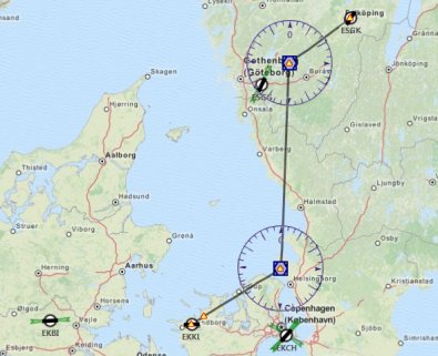 Leg 5 takes you past Copenhagen into Sweden. Passing the Trano VOR some 10nm north east of Kalundborg, head for the Sveda VOR. Before crossing the Öresund, you can divert a few miles further east to minimise the water crossing, and cross into Sweden at Helsingborg. Either way, once in Sweden, turn north and head for the Harry VOR. You can fly direct, or again, to minimise over-water flying, follow the E20 road along the coast towards Göteborg. After the Harry VOR, turn north east to find the small airfield of Falkoping, where you will land. Your dead reckoning navigation will be tested on this leg, as there are no radio navaids at or near Falkopong. Total leg distance is 187nm and will take around 1 hour 35 minutes. Leg 5 takes you past Copenhagen into Sweden. Passing the Trano VOR some 10nm north east of Kalundborg, head for the Sveda VOR. Before crossing the Öresund, you can divert a few miles further east to minimise the water crossing, and cross into Sweden at Helsingborg. Either way, once in Sweden, turn north and head for the Harry VOR. You can fly direct, or again, to minimise over-water flying, follow the E20 road along the coast towards Göteborg. After the Harry VOR, turn north east to find the small airfield of Falkoping, where you will land. Your dead reckoning navigation will be tested on this leg, as there are no radio navaids at or near Falkopong. Total leg distance is 187nm and will take around 1 hour 35 minutes.
Navigation Aids and Communications
| Trano VOR |
TNO |
117.40 MKHz |
| Sveda VOR |
SVD |
116.20 MHz |
| Harry VOR |
HAR |
117.50 MKHz |
| Kalundborg |
EKKL |
Unicom - 122.800 |
| Falkoping |
ESGK |
Unicom - 122.800 |
|
Leg 6
ESGK-ESSG |
Leg 6 is a straight track from Falkoping to Ludvika across wild sparsely populated country. Check your fuel before departure, and take your Arctic survival bag! There are no radio navaids again, so accurate dead reckoning navigation will be a must. If you are a true professional, you will overfly the intermediate airfield of Karlskoga (ESKK), 76nm into the flight. Flight time is approximately 1 hour and 05 minutes.
Navigation Aids and Communications
No radio navaids en route.
| Falkoping |
ESGK |
Unicom - 122.800 |
| Ludvika |
ESSG |
Unicom - 122.800 |
|
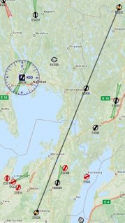
Leg 7
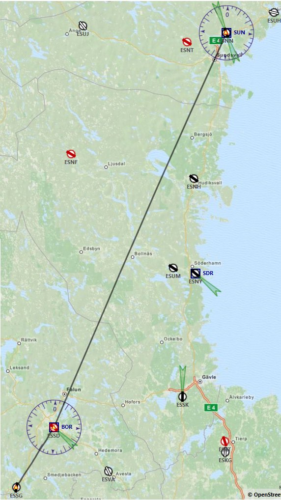
ESSG-ESNN |
 Leg 7, or leg 4 from Wangerooge, is another near straight line track. The route takes you first to the Borlange VOR 24nm after departure, then an easy VOR tracking leg of 138 nm to the Sundsval-Harnosand regional airport. As you cross the long Ljusnan Fjord about halfway along the second leg, you may spot the small town of Vallsta nestling on its southern shore, with its grass airstrip a couple of miles NW. Flight time is approximately 1 hour 25 minutes. Leg 7, or leg 4 from Wangerooge, is another near straight line track. The route takes you first to the Borlange VOR 24nm after departure, then an easy VOR tracking leg of 138 nm to the Sundsval-Harnosand regional airport. As you cross the long Ljusnan Fjord about halfway along the second leg, you may spot the small town of Vallsta nestling on its southern shore, with its grass airstrip a couple of miles NW. Flight time is approximately 1 hour 25 minutes.
Navigation Aids and Communications
| Borlange VOR |
BOR |
117.60 MHz |
| Sundsval VOR |
SUN |
113.10 MHz |
| Sundsval Rwy 16 ILS |
NNN |
108.70 MHz |
| Sundsval Rwy 34 ILS |
SNN |
110.30 MHz |
| Ludvika |
ESSG |
Unicom - 122.800 |
| Sundsval-Harnosand |
ESNN |
ATIS - 127.400 |
| Sundsval-Harnosand |
ESNN |
Tower - 118.100 |
|
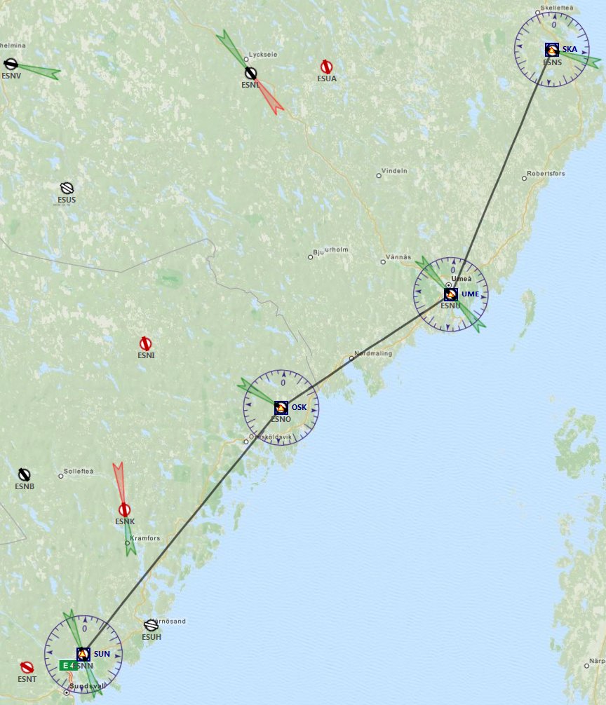
Leg 8
ESNN-ESNS |
 Leg 8, and the fifth leg from Wangerooge follows the coast in a northeasterly direction. An easy flight from VOR to VOR, you can spend a little more time sightseeing that navigating this leg. The coastline is rugged - shattered even - with hundreds of coves, cliffs and rocky inlets. There are also hundreds of small lakes inland in this pretty but sparsely populated region of our planet. Flight distance is 164nm and time is approximately 1 hour 25 minutes.. Leg 8, and the fifth leg from Wangerooge follows the coast in a northeasterly direction. An easy flight from VOR to VOR, you can spend a little more time sightseeing that navigating this leg. The coastline is rugged - shattered even - with hundreds of coves, cliffs and rocky inlets. There are also hundreds of small lakes inland in this pretty but sparsely populated region of our planet. Flight distance is 164nm and time is approximately 1 hour 25 minutes..
Navigation Aids and Communications
| Ornskoldsvik VOR |
OSK |
115.00 MHz |
| Umea VOR |
UME |
114.10 MHz |
| Skelleftea VOR |
SKA |
113.40 MHz |
| Skelleftea Rwy 28 ILS |
NS |
109.50 MHz |
| Sundsval-Harnosand |
ESNN |
ATIS- 127.400 |
| Sundsval-Harnosand |
ESNN |
Tower- 118.100 |
| Skelleftea Tower |
ESNS |
Unicom - 122.050 |
|
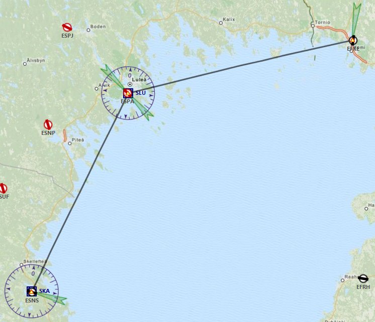
Leg 9
ESNS-EFKE |
 We continue north-easterly along the Baltic coast on leg 9, turning more easterly after Lulea VOR. to leave Sweden and cross into Finland at Tornio, or more precisely, out to sea somewhat, among the many islands in this the most northern shore of the Baltic Sea. Once again, if you are flying a single engined aircraft, you can simply follow the coastline. Tornio-Kemi airport is situated on the east side of the broad Kemijoki Estuary, so is easy to spot, in spite of having no VOR NDB on the airport. It does, however, have localiser NDBs for each runway and an ILS for runway 18. Flight time is approximately 1 hour. We continue north-easterly along the Baltic coast on leg 9, turning more easterly after Lulea VOR. to leave Sweden and cross into Finland at Tornio, or more precisely, out to sea somewhat, among the many islands in this the most northern shore of the Baltic Sea. Once again, if you are flying a single engined aircraft, you can simply follow the coastline. Tornio-Kemi airport is situated on the east side of the broad Kemijoki Estuary, so is easy to spot, in spite of having no VOR NDB on the airport. It does, however, have localiser NDBs for each runway and an ILS for runway 18. Flight time is approximately 1 hour.
Navigation Aids and Communications
| Lulea VOR |
SLU |
115.10 MHz |
| Tornio-Kemi Rwy 18 ILS |
KE |
110.90 MHz |
| Skelleftea Tower |
ESNS |
Unicom - 122.050 |
| Tornio-Kemi |
EFKE |
ATIS - 123.150 |
| Kemi Tower |
EFKE |
Tower- 118.100 |
|
Leg 10
ESKE-EFRO |
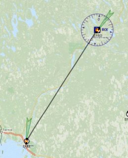 The last leg is only short, deliberately to give you plenty of time to get to Rovaniemi if there's a lot of traffic and you are held in orbit for some time. The whole flight is flown in Class D airspace, so you will need a departure clearance from Tornio-Kemi and permission to enter Rovaniemi's CTA which lies some 20nm along your track. Flight time is approximately 30 minutes direct, but expect to hold inbound to Rovaniemi. There are four possible approach frequencies and two Tower frequencies at this very busy airport. Check for full details once the event has been published by VATSIM Scandinavia. The last leg is only short, deliberately to give you plenty of time to get to Rovaniemi if there's a lot of traffic and you are held in orbit for some time. The whole flight is flown in Class D airspace, so you will need a departure clearance from Tornio-Kemi and permission to enter Rovaniemi's CTA which lies some 20nm along your track. Flight time is approximately 30 minutes direct, but expect to hold inbound to Rovaniemi. There are four possible approach frequencies and two Tower frequencies at this very busy airport. Check for full details once the event has been published by VATSIM Scandinavia.
Navigation Aids and Communications
| Rovani VOR |
ROI |
117.70 MHz |
| Rovaniemi Rwy 21 ILS |
RO |
109.10 MHz |
| Tornio-Kemi |
EFKE |
ATIS - 123.150 |
| Kemi Tower |
EFKE |
Tower - 118.100 |
| Rovaniemi Approach |
EFRO |
Several: See VATSIM Notam |
| Rovaniemi Tower |
EFRO |
Tower - 118.100 or 119.700 |
|
| VATSIM at Rovaniemi |
Rovaniemi is the administrative capital and commercial centre of Finland's northernmost province, Lapland. It lies just 8Km south of the Arctic Circle and it's most notable attraction is the Santa Claus village, which attracts 1000's of visitors in winter. VATEUD and VATSIM Scandinavia have a website devoted to the annual "Fly and Visit Santa" event. A link will be published here to the 2014 event once it is published. However, we do know that the event will be held on 13th December 2014 between 1800 and 2300UTC. The VATSIM briefings do not mention VFR, so we can create a nice surprise for them! Do join us. |
| Radio Discipline |
Take care not to let your Teamspeak chat cut across ATC, particularly when you can hear aircraft arriving back at Gloucester. Stop any conversation immediately the R/T comes alive, then continue if "he wasn't talking to us". This is difficult because when transmitting on Teamspeak you can't hear the R/T. So be brief on Teamspeak, and be aware that ATC might be trying to get through. If anyone hears an R/T message which seems to be being ignored, just say "ATC is calling G-CIXN" if you have identified the callsign, or "ATC is calling us" which is a cue for everyone to be quiet on Teamspeak until ATC call again (which they will). Remember too that if asked to "Stand By" by ATC, you do not reply - not even "Roger", but simply wait until you are called again.
Remember also that there are several different ATC frequencies in use, and you may not be able to hear when communications are taking place. Make sure you have set and know how to use a Teamspeak mute switch. |