Introduction
This is a series of tutorials and practical flying exercises prepared by CIX VFR Club to introduce members to online ATC and to enable them to learn at their own pace how to use it. Each lesson consists of a Groundschool section on aviation law and theory, and a practical exercise. From lesson 5 onwards, a discussion on flight planning is included and the practical exercise is a flight using the information in the lesson.
Planning a Flight
You have sat on the ground watching long enough - time to do some flying. In Lesson 6 you will get to go flying - Gloucestershire Airport south west to the Severn Bridges and back. In this lesson, you will plan that flight.
You may wonder why you are going to fly a crosscountry and not circuits round your home aerodrome. The answer is very simple - circuits are hard work and are more advanced flying than many people realize. A lot of mental energy and hand/eye coordination is needed to fly a circuit which compresses all your aircraft handling, basic heading and altitude holding, plus all the R/T patter that you haven't yet even begun to get off slickly, - into just six minutes - the average time taken to fly one circuit.
This particular lesson may seem long, for which I apologise, but all the different aspects of planning a VFR flight have to be covered for this first flight. Believe me, all this information will become familiar in time.
Charts & Guides
It has to be said that to fly as realistically as possible, you are recommended to obtain real world aviation charts if you can. They are normally updated annually, and real world pilots are required by law to fly with the current one. So if you visit your local flying club or flight school in April or May each year, when the new ones are published, you can usually obtain copies of the previous year's charts, which are perfectly good enough for flight simulator activities. They are drawn at 1 to 500,000 scale and are commonly known as 'the half mill charts'.
There are three which cover the whole of the UK; Northern Scotland; Northern England and Scotland from Liverpool to Glasgow; and Southern England from the Channel Islands to Liverpool. They are crammed with information, and if you were so inclined, you could spend a wet weekend doing little other than study them. Crucially, they show all the controlled airspace which you need to know about.
If this hobby turns out to enthrall you as it does so many others, you may also like to obtain a copy of one of the popular flight guides, e.g. Pooleys Flight Guide (from Pooleys), or the VFR Guide from Airplan Flight Equipment. You can also often get a copy of the previous year's Pooleys or AFE Flight Guide from sources such as eBay.
I bought my first Pooleys in 1991 purely for Flight Simulator and 3 years before I learned to fly for real. It's a fascinating book and contains almost everything you need to know about VFR flight. Like charts, it is republished every year, so you might be able to get hold of an old one.
Groundschool
For every flight, you need to do quite a lot of preparation. Every minute spent preparing for a flight on the ground saves 5 minutes panic in the air! First you need to do some reading. There's quite a lot of reading as always, unfortunately, particularly as it is your first flight. Don't worry about understanding it all at once. Topics will be introduced as they are needed throughout these on-line flight lessons.
Reading
Study exercises 20, 21 and 22 of the CIX VFR Club Flight Training Manual, available on the Club website at
These exercises cover your departure from the airfield after take off, and the planning for and arrival back at Gloucestershire.
The essential ATC dialogue for this flight is included later in this lesson, but you should also read Chapters 1, 2 and 3 of the Club's Radio Telephony Manual which may be found on the web site.
As a new pilot, be aware that most controllers you are working are unlikely to be as inexperienced as you, although some may be. Obey their instructions, and ask for help if you are unsure of what to do. You can also put 'Student Pilot - first on line flight' in your flight plan. Also, read the Club 'Code of Conduct' document accessed from the Membership page of the web site. It contains a lot of useful advice.
Doctor Foster went to Gloucester
A word about Gloucester. Gloucester (rhymes with 'Foster') is a city in the south west Midlands, and the county town of Gloucestershire (rhymes with 'Fostersheer'). The Aerodrome is officially known as Gloucestershire, but its radio callsign is 'Gloster' (spelled like that).
Flight Planning
Distances and Bearings
In Lesson 7 we will explore how to measure and calculate distances, bearings and times, but for this flight, they have been measured and calculated for you.
The Route Plotted on a fragment of the Aeronautical Chart
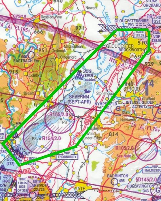
You will depart Gloucestershire on a heading of 270o crossing the River Severn and the A417 near Maisemore. Level out at 2000 feet. After crossing the A417, turn left heading 230o and fly along the north bank of the Severn with, on your left, both the river and the railway which follows it. Make sure you avoid flying within the area of the two purple circles which are Restricted Zones up to 2000 feet. That's what the R<number>/2.0 alongside them means. The key to all these unfamiliar terms and symbols may be found at the bottom of the chart.
The Old Severn Bridge will shortly come into view, and once past it, turn left again, heading 150o to fly parallel to the bridge. As you cross the south bank of the river, you will turn left, heading 070o, to fly over the distinctive and large village of Thornbury. You continue on that heading until you have crossed the M5 motorway, then turn left heading 040o and follow the M5 northwards, keeping it on your left always.
You cross the towns of Dursley (where Lister diesel engines are made) and Stonehouse, with the larger town of Stroud passing by on your right. At Stroud you should contact Gloucestershire ATC for 'joining instructions'.
As you approach Gloucester city, you will cross over the disused aerodrome of Brockworth and should see the white roofs and large green open space which signifies Gloucestershire Airport. In Flight Simulator, airfields 'cheat' because they twinkle due to pixilation on the monitor screen, and thus are normally more visible than they are in real life.
Waypoints and Track Lines
That is your trip. Note the landmarks mentioned (called 'waypoints' in aviation navigation), which you use to make sure that you always know where you are. No point in daydreaming about how well you are doing and then not knowing if you have passed Stroud or not! In particular, you will see that as you cross the Severn, you are heading straight towards Bristol Filton aerodrome, which, incidentally, has the widest runway in the UK - 91 metres. It was built that wide, and also very long, (2467 metres) for the highly innovative and mighty propeller driven Brabazon airliner (bigger than a Boeing 747) which was built there in the late 1940s, but unfortunately never got beyond test flights before the jet engine began to command aircraft design.
You will also note that the route, the track line, is marked in green. This is because green is the least common colour otherwise used on the chart. You can use any colour you wish, but make a big bold line so that you can see it instantly when just glancing at the chart.
The chart segment above shows the route. This of course is the Aeronautical chart and you might find it helpful for early trips to look up the route on a road map too.
Can't Land at Gloucester
What would you do if, when you contact Gloucestershire to rejoin for landing, the ATCO tells you that the Airport is closed because of an emergency? You have to go somewhere else of course. (This actually happened to a real world student pilot on her first solo in 2006). Part of your preparation is to decide on an “Alternate” - an aerodrome where you can land. Your planning for this part of the task is to choose a route from your intended destination (not your departure point or anywhere else) to the nearest suitable aerodrome and to keep that plan handy - headings, times, altitudes, in exactly the same way as your main plan.
In the example above, we have chosen Wellesbourne Mountford EGBW near Stratford. Wellesbourne mountford was chosen because a direct route is possible without infringing any controlled airspace, danger areas etc. There is a Restricted Area at Evesham, but it only applies to Helicopters and up to 2,200 feet. The route is 27 nautical miles on a track of 048° and will take 16 minutes at 100 knots. In subsequent lessons you will be able to determine your own alternate and plan a route to it.
Controlled Airspace
For this trip you don't have to worry about Controlled Airspace apart from Filton's Aerodrome Traffic Zone (ATZ) which you must avoid, and Gloucestershire, where you will need permission to re-enter for landing.
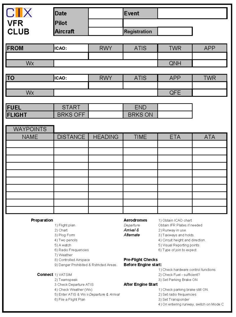
Completing the Pilot's Log
The Plog filled in before take off
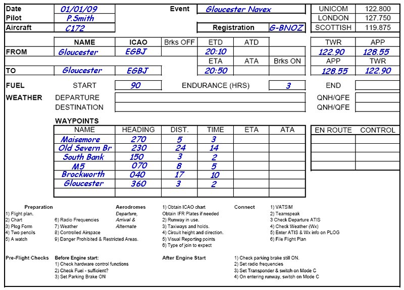
Finally we need to cover how to complete your Pilot's Log, or PLOG. This is what your PLOG should look like before departure. First enter the basic data - Aircraft type, your name, Departure and Arrival airfields and radio frequencies. On VATSIM, official ICAO codes are used, because the software needs to recognise the codes, which are less prone to spelling errors than aerodrome names. We all know what computers do with spelling errors. If we hadn't done it for you this time, you would also enter the waypoints, headings, distances and times for each leg, as you would have calculated or measured them. Finally enter your estimated time of departure (ETD) and Estimated Time of Arrival (ETA) back at Gloucestershire, because this must be entered in your formal Flight Plan.
You need to keep the Plog handy throughout the flight, because you will adding to it as you fly. Let's work through an example. Either just before, or as soon as you safely can after takeoff, scribble your Actual Time of Departure in the ATD box - scribble being the operative word while flying. Let's say it was 20:15.
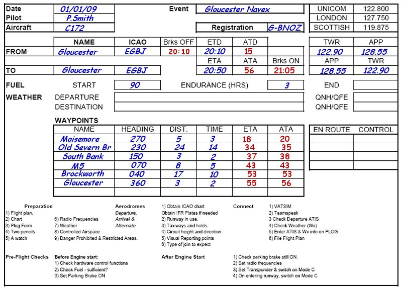
The completed Plog after flight
Now you can add the estimated Time to Maisemore (3 minutes) to that time to enter the ETA for Maisemore, which will be 20:18. However, only enter '18' as the '20' is obvious.
Let's assume that as you pass Maisemore you check your watch, and it's 21:20. That's 2 minutes later than estimated. Enter '20' in the Maisemore ATA box. Now you can immediately enter the ETA for Old Severn Bridge - '20' plus '14', and enter '34' in the Old Severn Bridge ETA box.
Continue entering ETAs and ATAs in this way until the end of the flight, and if you always fly with that discipline I assure you that you will rarely get lost. The last entry on your plog should be the time that you stop on the apron and shut down the engine.
The weather code will be covered in lesson 7.
Fuel
You need to decide how much fuel you need. In the real world, you are required by law to have 45 minutes reserve fuel as a minimum when you land, and you are flying 'as real as it gets'. So you need whatever fuel the flight requires plus that reserve. Now I can tell you that the Cessna 172 burns 30 litres or 8 U.S. gallons (USG) of fuel an hour. Your estimated airborne flight time is 36 minutes, which has been calculated for you for this lesson, but that's not all. We need to allow 10 minutes for taxiing at both ends and 10 minutes for the take off and climb to 2000 feet.
Here is the fuel calculation: -
| FUEL | |
|---|---|
| Element | Minutes |
| Taxiing at Gloucestershire | 5 |
| Take off and climb | 10 |
| En route | 36 |
| Taxiing at Gloucestershire | 5 |
| Reserve | 45 |
| Total | 101 |
So you need 101 minutes of fuel, which translates into 50.5 litres. So as long as you have, say 51 litres (14 US gallons) of fuel on board, you are safe to fly.
There is a handy spreadsheet on the club web site containing a number of formulae and conversions, including litres to gallons etc.
On the formal Flight Plan (see below), you are required to enter your fuel carried. This is often called “Endurance” and is entered as a time. If you are burning 30 litres an hour, and say you have 90 litres on board, then you enter “Fuel on board” as 3 hours - 0300 in the FSInn Flight Plan, separate boxes for hours and minutes in the SB Flight Plan.
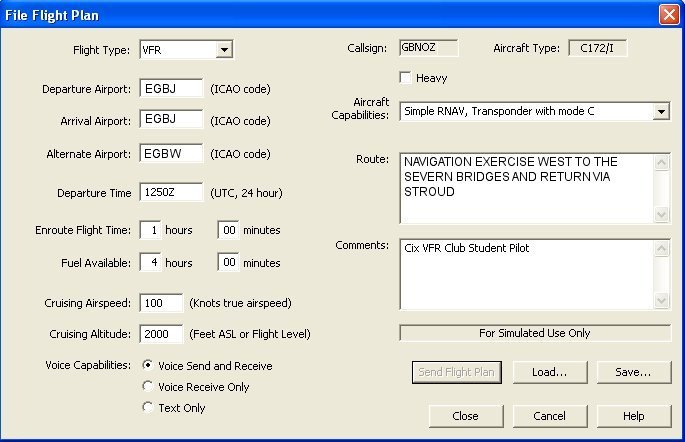
The Formal Flight Plan
This is not the same as the flight planning described above. The formal flight plan is entered in FSInn or Squawkbox and is transmitted to your departure and arrival aerodromes, if they are open on VATSIM. Once you have completed your flight planning, you can then prepare your formal Flight Plan. Examples are shown below.
An FSInn Flight Plan A Squawkbox Flight Plan